 This is my favorite park in Middle Tennessee, but I had never hiked this trail. I attempted it a few years ago on my birthday camping trip. It was hot. Of course it was hot, it was August. I stopped to give my black lab Hannibal some water. It was then I discovered that I left the extra water for him in the car. I tore my backpack inside out. I knew there would be no water for at least another mile and in that searing heat, he would be near heat exhaustion. He was already panting hard. I aborted the hike. I would discover when I arrived home (90 miles away), that I was missing my glasses. I returned 2 days later, and, sure enough found my glasses. Laying in the middle of the trail, right where I tore open my backpack. Lesson learned.
No, that’s not me. That’s Harold, my hiking partner for the day, at Stone Door.
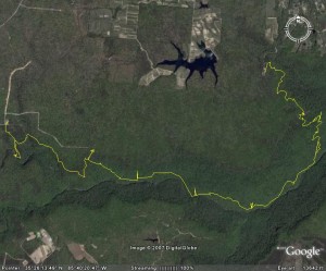
Stone Door parking lot (near Beersheba Springs) to Greeter Falls (near Altamont) parking lot
Distance: 7.5 miles
Max Elevation: 1888 ft
Total Elevation climb: 1547 ft
Trail Type: single track dirt, rocky
Temperature: 80s, sunny and hot
Time: 3:11 moving, 2:33 resting
Significant Features: the gulf, a few overlooks and more trees!
The total climb number below doesn’t do this hike justice. Most of that 1,500 feet of elevation climb occurs in just 1 mile. It’s a haul.
The hike starts out on the easy 1 mile long Stone Door Trail. Oddly enough, it leads you to Stone Door, a 10 foot wide crack in the cliff. A tree grows in the crack and somebody thought it looked like a door knob. Whatever. This is an easy hike and I would encourage ANYONE to hike this trail to the door and the overlooks. The views are simply breathtaking and are the most accessible in the park. A friend of mine proposed to his now wife here. It’s that good.
I then veered off down through the door on the Big Creek Gulf trail. And descend I did. For a while. A long while. Get the picture? The trail is extremely rocky down here. It’s not bouldering, but I did have to watch my step. And when we arrived at Big Creek, guess what? No water. That’s right, Big Creek runs into a sink a few miles upstream. According to my friend, Ranger Bill, he’s surprised this section shows up as a blue line on a map. This is bad news because at this time of year, I figured there would be SOME water here for Hannibal to drink. A couple of miles up, I found a seep and got a nice cool shower and water for Hannibal.
I start heading on, and start a gentle climb up and out of the gulf. Just when I can’t get to the dry creek easily anymore, guess what? That’s right, the creek was a torrent. I don’t know how long it took to get back up onto the plateau. Let’s just say, I didn’t set any land speed records. But I made it, back to Alum Gap (a great place to overnight, I might add).
I should tell you that the Greeter Trail, which we are hiking back to the car we dropped, isn’t marked very well from this direction. I even had to ask directions! It’s just a few mile hike over to Greeter Falls. This falls is also more accessible than most in the park, so its worth the trip. Today I can tell we’re in a drought. A lot of water, but not near what it should be for springtime. There’s plenty for Hannibal though!
It’s about 3/4 of a mile back to the parking lot where we dropped Harold’s car. Nice to ride for a little while. Harold dropped me off at Stone Door, where I camped for the night. He returned to the city for an evening with friends.
Sorry for the lack of pictures. My camera battery died on the trail.
Links:
Pictures are HERE
Park website is HERE
Park friends website is HERE
