 This weekend, I didn’t go on a hiking trip. That’s right, after hiking every weekend for over 3 months (save Easter), I didn’t plan to go hiking. Instead, I planned to help BUILD a trail.
History
The Cumberland Trail was first envisioned nearly 40 years ago by a number of conservationists who formed the Tennessee Trails Association. TTA worked with the state of Tennessee to pass the Tennessee Trails System Act in 1971 and the work began building in Tennessee’s wildlife management areas, state forests and state parks. Seeing that the project needed a body of its own, TTA formed the Cumberland Trail Conference in 1997. In 1998, the Cumberland Trail became Tennessee’s 53rd state park and its first linear state park.
TODAY
The route begins in southeast Tennessee west of Chattanooga. When
completed it will stretch over 300 miles to Cumberland Gap north of
Knoxville, skirting the eastern edge of the Cumberland Plateau along
the way. 165 miles of the trail are completed and open for hiking. The remaining sections are in various stages of completion (land acquisition, awaiting trail construction, etc.) Check out the Cumberland Trail Conference for maps to the open sections.
The trail is a partnership with the Cumberland Trail Conference, and state of Tennessee’s State Parks, Wildlife Resource Agency, Department of Environment and Conservation, Department of Tourist Developemnt and Department of Transportation. Other partners include private organizations, foundations, and the National Park Service (Cumberland Gap National Historic Park and the Chickamauga and Chattanooga National Military Park). This is definitely one of my generation’s premier public-private partnerships.
FUTURE
The Cumberland Trail is a key section of a still under development western alternative to the Appalachian Trail.
WHAT DID I DO?
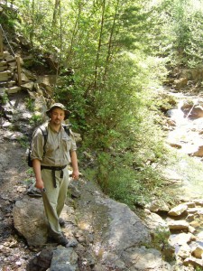
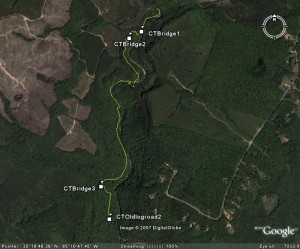
Well, first I got to work with some fine trail builders from across our state. Our crew built around 30 steps and gargoyled several sections of trail. We also built a cribbing wall. And on Sunday, I got to map a section of the trail with my GPS (ok, so that DID involve hiking the trail).
Trail: Cumberland Trail
Distance: 1.6 miles
Max Elevation: ~1,250 feet
Total Elevation climb: 396 feet on the return trip
Trail Type: single track dirt
Temperature: 80s, sunny and warm
Time: 1.5 hour moving with 15 minutes of lolly gagging
Significant Features: creeks, cascades, and rock overhang
The short section I hiked has a number of mined areas, which were reforested with pine. Board Camp Creek gushes off to the left as I hike out. The water from the creek tasted wonderful (I filtered it first as always). My decent was made easier by the steps that had been installed (way to go crew!).
The last pictures in the album are of a creek on private property that is obviously polluted with mine runoff.
I have been wanted to learn the craft of trail building for some time now. And learn I did. I asked a lot of questions, but everyone was very patient with me. I’m hoping to go back toward the middle of May to learn more.
Did you ever think while hiking a trail that someone actually had to build this? They had to pick the route, cut the trees, clear the brush, remove the duff, install the steps and cribbing. And its not easy work let me tell you. Our crew consumed plenty of water and Vitamin I.
I challenge each of my hiker readers to work on building or
maintaining a trail somewhere. And when you do, drop a comment on this
post to let me know about it! As a hiker, there is no more rewarding experience than working on a trail, knowing generations from now my grandson may ask those same questions.
Download the Google Earth track
Pictures
Reference links:
Wikipedia
Tennessee State Parks
Cumberland Trail Conference
Friends of the Cumberland Trail
