 I finally got back my 4Runner back in operation and decided to venture a little further from home that I have lately. The South Cumberland State Park is one of my favorite places on the planet. SCSP is 11,000 acres of ten different parcels scattered around the southern end of the Cumberland Plateau. I ventured to one of my recently discovered areas, Grundy State Forest Natural Area.
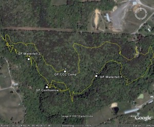
Trail: Grundy Forest Day Loop
Distance: 2.5 miles
Max Elevation: 1896 feet
Total Elevation climb: 305 feet
Trail Type: single track dirt
Temperature: 70s, sunny and warm
Time: 1 hour moving with 1 hour of lolly gagging
Significant Features: creeks, cascades, and a nice sized bluff near one end of the loop
I discovered Grundy Forest about 2 years ago in a brochure at the state park’s visitor’s center. I finally decided to go there about a year ago and I’m glad I did.
Grundy Forest is the northern terminus of the 12 mile Fiery Gizzard trail. The day loop starts (I started by going right) walking through forest mainly for about 3/4 mile. I noticed a small glade to my left.
Today, the trail is more crowded than I’m used to. A group comes by with about 5 dogs. I stopped to let them by so Hannibal, my dog, won’t be fretting and I wouldn’t be rushed.
I make my way down to the creek and I sit and read while Hannibal investigates the creek. We move on along the creek until we reach the intersection with the Fiery Gizzard Trail. I decide to hike over to the confluence of the Big and Little Fiery Gizzard creeks.
As we’re headed back up, the geography changes slightly as we pass the large bluff. Hard to believe we’ve already made it through this loop. My buds and I are planning on backpacking Fiery Gizzard in a few weeks.
Map of Grundy Forest Natural Area
